Caughlin Ranch
BIRDING GUIDE
3/29/2024
WHAT TO EXPECT
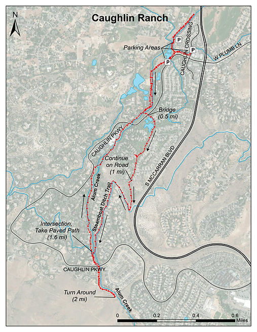
The Caughlin Ranch subdivision, located on the northeastern slope of the Carson Range in West Reno, has many walking paths along creeks, past ponds, through beautiful landscaped and natural areas. A paved path follows Alum Creek through the area, intersecting with the Steamboat Ditch. This guide is based on a 4 mile loop route along paved paths passing many small ponds, a short steep rocky dirt single track to access the Steamboat Ditch, and the 2-track dirt Steamboat Ditch trail. Many other walking options are possible for birding in this area.
BEST TIME OF YEAR
Year-round, with the most abundant species and diversity in the spring and summer
NOTABLE SPECIES
View: eBird Hotspot
The ponds usually have a few different duck species, including American Wigeons, Gadwalls, Buffleheads and Hooded Mergansers in late fall and winter. Great Horned Owls, Red-tailed Hawks and Cooper’s Hawks nest in the trees. Red Crossbills have occasionally been seen. Pinyon Jays utilize the area along upper Alum Creek. Over 120 species have been observed in the Caughlin Ranch area.
HOW TO GET THERE
Google Map of the Area
From the I-80/I-580 Interchange head west 4.2 miles. Exit I-80 at West McCarran and head south on McCarran for 1.5 miles. Turn right/west on to Caughlin Parkway (at the intersection where Plumb Lane begins to the East). Park along Caughlin Parkway past Caughlin Crossing, or turn right at Caughlin Crossing and park along the street.
POPULAR BIRDING ROUTE
Walk west along the paved path on the right/north side of Caughlin Parkway. Look for ducks and geese in the ponds along the path. Watch for Mountain Chickadees, warblers, Ruby-crowned Kinglets, vireos, finches, goldfinches, robins and jays in the trees, sparrows and towhees in the shrubs.
At approximately .5 miles, a paved side path goes left across a bridge and crosses Caughlin Parkway. Take this path past a few ponds and through open space between houses, winding gradually uphill. Be on the lookout for birds on feeders and in berry-producing shrubs along the way.
After approximately 1 mile from the start, the paved path ends at a road. Walk a short distance up/right and take the paved path/road on the left (green gate which is usually open). Continue up the pavement, looking for bushtits, Blue-gray Gnatcatchers, warblers, vireos, towhees and jays. Continue on the short, steep rocky single track up to the Steamboat Ditch trail.
From the Steamboat Ditch trail, take a look around for raptors and birds perched in the trees below and above the trail. Look for Cedar Waxwings when berries are present. Continue to the right/west along the trail for approximately another .6 miles, crossing streets and continuing behind houses.
There is a dip in the trail where water may be present in the spring. After the dip, the Steamboat Ditch intersects the main paved path along Alum Creek. Turn right/down to return back to the parking area.
To continue birding, turn left/uphill and follow the path, going through a grove of trees and under the roadway. Alum Creek is to the left, with mature Jeffrey Pine trees and willows along the creek and sagebrush/bitterbrush uplands on the right. Look for riparian species in the willows.
The turn-around is where the paved path along Alum Creek turns to dirt. (The paved path crosses a bridge and continues uphill to street access). This is approximately 2 miles from the start. (For a longer adventure, continue up the dirt single track along Alum Creek.)
Return down the main paved path for 1.6 miles to the parking area.
To continue birding near the parking area, take the paved path to the left (after the last pond). Check the willows for wrens and warblers. Look for Cooper’s Hawks in the trees. Walk along the creek until it turns left toward Mayberry Landing. Turn around and return to the parking area.
Optional Side Trips: Explore the many paths in this area.


4/17/21 - Caughlin Ranch ponds